Otorafit - Gamified Fitness Territory App
Gamified fitness application where users claim geographical territories and earn points, featuring location-based challenges, community interaction, and real-time GPS tracking.
Client
Custom Project
Timeline
Phase 1: 8 weeks | December 2024 - January 2025
Role
Full-stack Mobile Developer - Frontend, Backend, Maps Integration, Geolocation Logic
Technologies Used

Project Objective
Otorafit needed an innovative mobile application that combines fitness tracking with gamification and territorial exploration. The app aims to motivate users to stay active by turning real-world locations into claimable territories where users earn points. The platform required precise GPS tracking, complex geographical calculations for territory boundaries, a community system for user engagement, and admin controls for content management. Phase 1 focused on core features: authentication, territory claiming mechanics, points system, and community foundation.
The Challenge
Building a location-based gamified fitness app presented unique technical challenges: Complex Geolocation Logic - Implementing accurate territory claiming using GPS coordinates, detecting when users enter predefined or custom territories, and preventing territory overlap or gaming the system. Real-Time GPS Tracking - Efficiently tracking user location in background without draining battery, handling GPS accuracy issues, and working across different devices and OS versions. Geographical Calculations - Using Turf.js for complex operations like point-in-polygon detection, area calculations, territory boundary verification, and distance measurements between user and territories. Gamification System - Designing fair point allocation logic, preventing cheating or GPS spoofing, tracking user achievements, and maintaining engagement through rewards. Community Management - Building admin panel for post creation, moderation, and content management while ensuring smooth user experience in community feed. Cross-Platform Performance - Ensuring consistent experience on both iOS and Android using React Native and Expo while handling device-specific GPS and map rendering differences.
The Solution
We developed a cross-platform mobile app with advanced geolocation and gamification features: React Native with Expo providing unified codebase for iOS and Android, leveraging Expo's location services for background GPS tracking and native performance. Google Maps Integration implementing interactive map display, custom territory markers, user location indicator, and real-time map updates as users move and claim territories. Advanced Geospatial Logic using Turf.js for precise geographical calculations including point-in-polygon detection for territory claiming, area measurement for territory size validation, distance calculations, and custom territory boundary drawing. Territory Claiming System with two modes: predefined territories (set by admin) and custom territories (user-drawn areas), point allocation based on territory size and difficulty, prevention of duplicate claims and territory overlaps. Authentication System implementing secure user signup/login with JWT tokens, user profile management, and session handling across app restarts. Points & Gamification Engine tracking user points from territory claims, achievement system for milestones, leaderboard logic (prepared for Phase 2), and engagement metrics. Community Platform allowing admin to create, edit, and delete community posts, users to view community feed, and foundation for future social features like comments and reactions. Backend API using Node.js and Express for user authentication, territory data management, point calculations, and community post storage in MongoDB.
Key Features
Territory Claiming
Claim predefined areas or create custom territories using GPS and earn points for exploration
Dual Territory Modes
Choose between admin-defined territories or draw your own custom claimed areas
Real-Time GPS Tracking
Background location tracking detects when users enter claimable territories
Points System
Earn points based on territory size, difficulty, and exploration achievements
Google Maps Integration
Interactive map showing territories, user location, and claimed areas in real-time
Community Feed
Admin-managed community posts keeping users engaged and informed
Geospatial Calculations
Turf.js powered territory validation, area measurement, and boundary detection
Cross-Platform
Native iOS and Android experience with single React Native codebase
Technology Stack
Frontend
Backend
Mobile
Infrastructure
Screenshots

User profile and Activity showing claimed territories, total points, and achievements
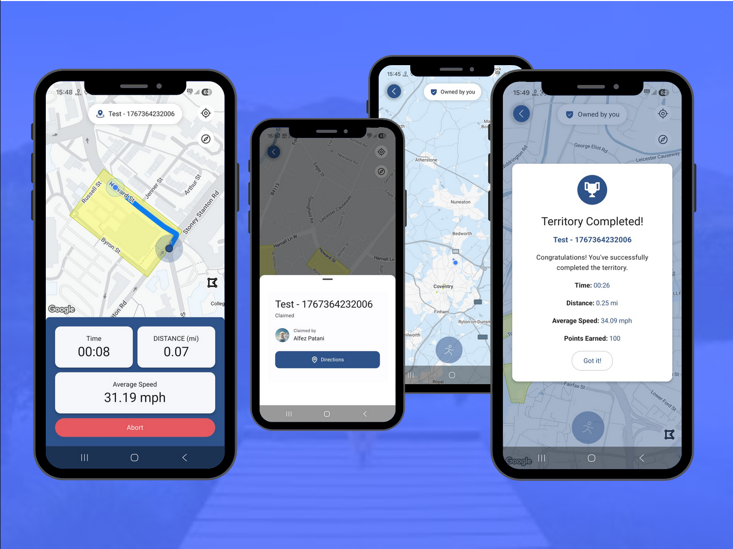
Interactive map showing predefined territories and user current location

Community feed displaying admin posts and user engagement features
Results & Impact
Phase 1 Completed
Phase Status
Predefined & Custom territories
Territory Types
Within 10-20 meters
GPS Accuracy
iOS & Android native
Platform Support
Turf.js integration
Geospatial Engine
Battery-optimized GPS
Background Tracking
Lessons Learned
This project was our deepest dive into mobile development and geolocation technology. We gained extensive experience with React Native and Expo, learning to optimize background location tracking for battery efficiency. Working with Turf.js taught us complex geospatial calculations and how to handle real-world GPS accuracy issues. The gamification aspect challenged us to think about user engagement, fair point systems, and preventing exploitation. Building both predefined and custom territory systems required careful database design and efficient map rendering. This project significantly enhanced our mobile development skills and prepared us for future location-based applications.
Interested in a Similar Project?
Let's discuss how we can build something amazing for your business.